MapInfo Pro

 View Only
Expand all | Collapse all

What has happened to my aerial image and how do I fix it?

  • 1.  What has happened to my aerial image and how do I fix it?

    Posted 07-10-2019 00:08
    Hello all

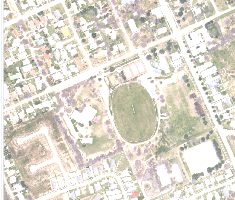
    This opens totally fine in v16 and v12.5 but for some reason it opens really messed up in v17. Is there a setting somewhere that needs tweaking?

    First image is v17 and second v12.5

    Many thanks
     

    ------------------------------
    Rebecca Marks
    GIS & Environment Officer
    Greater Hume Council
    NSW Australia
    ------------------------------


  • 2.  RE: What has happened to my aerial image and how do I fix it?

    Employee
    Posted 07-10-2019 19:07

    Hello Rebecca,

    This looks to be a known issue and it's related to MapInfo Pro v17.0 introducing 32-bit rendering by default. This results in some images becoming washed out or faded when rendered in v17.0.

    To resolve this, please follow the instructions in the knowledgebase article below.

    https://support.pitneybowes.com/VFP05_KnowledgeWithSidebarHowTo?id=kA11E000000PR0USAW&popup=false&lang=en_US


    Hope this helps!


    ------------------------------
    Dave Kuo
    Pitney Bowes Australia Pty Ltd
    Australia
    ------------------------------


  • 3.  RE: What has happened to my aerial image and how do I fix it?

    Posted 07-10-2019 20:01
    Thank you Dave!

    Unfortunately that didn't help at all.

    I checked the box for "Disable alpha channel" and then I double checked the xml file as well and my image is still not displaying correctly.

    I'll try restarting the whole PC just to be sure.


    ------------------------------
    Rebecca Marks
    GIS & Environment Officer
    Greater Hume Council
    NSW Australia
    ------------------------------


  • 4.  RE: What has happened to my aerial image and how do I fix it?

    Posted 07-10-2019 20:12
    Restart didn't help.

    However I have noticed that when I hover over the greyed out "Advanced color" button it says I need to open a raster file to enable it. I have a raster open, but it's a seamless table. I tried opening one of the individual files and the option is now available, however it is still set to the recommended "disable alpha channel"

    Any further help would be greatly appreciated

    ------------------------------
    Rebecca Marks
    GIS & Environment Officer
    Greater Hume Council
    NSW Australia
    ------------------------------


  • 5.  RE: What has happened to my aerial image and how do I fix it?

    Employee
    Posted 07-10-2019 20:13
    Sorry to hear this. Can you please verify the exact version of MapInfo Pro you are using including the build number? This can be found under PRO tab > About

    ------------------------------
    Dave Kuo
    Pitney Bowes Australia Pty Ltd
    Australia
    ------------------------------


  • 6.  RE: What has happened to my aerial image and how do I fix it?

    Posted 07-10-2019 20:17
    Hello

    It is v 17.0.3 build 19

    ------------------------------
    Rebecca Marks
    GIS & Environment Officer
    Greater Hume Council
    NSW Australia
    ------------------------------


  • 7.  RE: What has happened to my aerial image and how do I fix it?

    Employee
    Posted 07-10-2019 22:27
    Thanks Rebecca. I have decided to open a support case on your behalf and will reach out to you directly to try to get to the bottom of this issue.

    ------------------------------
    Dave Kuo
    Pitney Bowes Australia Pty Ltd
    Australia
    ------------------------------


  • 8.  RE: What has happened to my aerial image and how do I fix it?

    Posted 07-10-2019 23:18
    Great! thanks

    ------------------------------
    Rebecca Marks
    GIS & Environment Officer
    Greater Hume Council
    NSW Australia
    ------------------------------


  • 9.  RE: What has happened to my aerial image and how do I fix it?

    Posted 07-11-2019 02:51
      |   view attached
    Hi Rebecca,
    Please find the attached Six Aerial TileServer Table attached.

    Let me know if you get the same results with that.

    If you do not, please check the transparency of the layer or the order of the layers (if another semi transparent layer is over top it may give it the appearance of being washed out).
     
    Hope this helps.

    ------------------------------
    Steven Graham
    Software Architect and Distinguished Computer Engineer
    Tenterfield Shire Council
    ------------------------------

    Attachment(s)

    zip
    SixAerial.zip   751 B 1 version


  • 10.  RE: What has happened to my aerial image and how do I fix it?

    Posted 07-11-2019 02:57
    Hello

    Yes the tile works fine (though did throw a few 404 errors).

    I'm just waiting to send one of our TIF files through to PB, Dave is setting up an FTP so I can send it. The TIF works fine on other versions on this PC

    Cheers

    ------------------------------
    Rebecca Marks
    GIS & Environment Officer
    Greater Hume Council
    NSW Australia
    ------------------------------


  • 11.  RE: What has happened to my aerial image and how do I fix it?

    Posted 07-11-2019 18:29
    Yeah I got 404 errors from LPI's servers too. Thats the sole reason I wrote a Tile Proxy script on our web server which caches the tiles locally for much improved speed.

    Not sure if MapInfo has any tile caching options or retry on 404 for tile servers, but that would possibly eliminate these issues.

    ------------------------------
    Steven Graham
    Software Architect and Distinguished Computer Engineer
    Tenterfield Shire Council
    ------------------------------


  • 12.  RE: What has happened to my aerial image and how do I fix it?
    Best Answer

    Posted 07-14-2019 19:57

    In case anyone is wondering where this is up to...

    I have followed the instructions to correct the image
    It did nothing
    I tested it again with a single image (as opposed to my seamless table)
    It did nothing

    I thought I'd fiddle with the other settings under Advanced Colour (not available for seamless tables) and changing the Display Mode from RGB to Pseudo Color and then back to RGB - FIXED IT!!

    The corrected file stayed corrected when reopened, and inside the seamless table when all the other pieces stayed uncorrected.

    The rest of the image files on this pc need to be adjusted one at a time the same way to get the fix to stick. It is time consuming and annoying but it works for now.


    ------------------------------
    Rebecca Marks
    GIS & Environment Officer
    Greater Hume Council
    NSW Australia
    ------------------------------


  • 13.  RE: What has happened to my aerial image and how do I fix it?

    Posted 07-18-2019 17:06

    Hi Rebecca,

    Are your images in ECW or JPEG2000 format?

    An issue has just come to my attention for images in that format, which produces a result very similar to the screen-shot you posted. If these images have variable opacity values then, by default, the ECW/JP2 driver converts pixels that are more than 50% transparent to empty pixels. I think we can just turn this behaviour off now because users can use the "Display alpha channel" switch. I will update this for release 17.04.

    However, you posted above that you fixed the problem, which tends to imply there was some kind of validity issue with the rendering XML stored in the GHX file. So maybe this transparency issue is not related to your problem.

    Regards,
    Sam.


    ------------------------------
    Sam Roberts
    Engineer, MapInfo Pro Advanced (Raster)
    Australia
    ------------------------------


  • 14.  RE: What has happened to my aerial image and how do I fix it?

    Posted 07-18-2019 19:30
    Edited by Rebecca Marks 07-18-2019 19:30
    Hello

    The switch for alpha channel did not work at all, until I swapped the image to false colour and then back again. Given how many tables I had in my seamless table, it was just not viable to do it for every single file. PB support believed I should just have need to turn that switch on the once, but obviously that didn't work in this case, so it's still with them.

    In the mean time I've had  a terrible time trying to get the aerial photos to even open to test the latest potential solution, and have rolled back from v17 to v16. The images are currently displaying fine but I've had to drag some of them onto my desktop to get them to load in a reasonable amount of time (even using v16). Leaving them on the network drive where they have lived for a number of years while we ran much older earlier versions of MIPro was just timing out and crashing the newer versions.

    I've had a very frustrating week when it comes to images.

    ------------------------------
    Rebecca Marks
    GIS & Environment Officer
    Greater Hume Council
    NSW Australia
    ------------------------------