Hi Peter,
Thank you
Made some headway in the end. Have sent what I can and the work flow I took to Support: Discover & MIP
Have issues with other layer as well in WA e.g. National Parks and Reports files. These all have overlapping objects and this is where the issue is. No issue whatsoever in MIP with single objects (e.g. no overlaps) even if its for all of WA/AUS.
Cheers
Original Message:
Sent: 6/2/2021 6:06:00 AM
From: Peter Horsbøll Møller
Subject: RE: Geometry clean tool (s) for TAB file – polygons please | MapInfo Split Tool 'does not work' on overlapping Obj. / Features
Hi Mike
Check Regions
No, Check Regions only highlights where the problems are. From the help:
Check Regions detects errors in your data that may produce problems or incorrect results when various operations are performed. There are a couple of rules associated with the Check Regions dialog box. You must select the regions you want to check before you use the Check Regions command. The objects must reside in one layer, and they must all be closed objects. MapInfo Pro places the Check Regions results in the current editable layer in the active Map window. There is no data aggregation or disaggregation performed on this data and no data is associated with the objects created. The options for the Check Region dialog box are explained in detail in this section. To see examples of the gap and overlap regions, see the illustrations at the end of the Cleaning Objects section.
The Self-Intersection Detection option helps you to check your regions for areas that cross over themselves, which could cause errors later on. When you use this option, the Check Regions command creates a point at the location where the data may self intersect. To change the symbol used to indicate self intersections, click the Style button in the Self-Intersection Detection group to display the Symbol Style dialog box. You can make the desired changes here.
You can check regions/tables for various aspects of incorrect data, or possible incorrect data, which may cause problems and/or incorrect results in various operations. Only region objects will be checked. The region objects will be checked for self-intersections and will check for overlapping objects if desired.
Some of the problem areas checked include:
- Line segments within a region, which cross each other.
- Nodes within a single polygon of a region where the polygon touches itself. The node will have more than 2 line segments emanating from it. This case can be broken down into two other instances. Given a polygon that has 2 looped sections, if the path traced by the nodes of the polygon follow a cursive figure 8, then this is called a figure 8. If the same 2 looped polygon can have its path traced as a cursive capital letter B, then this is termed a Bow Tie. Figure 8's are considered to be worse than Bow Ties. For example, the Area of a Figure 8 will always be incorrect, while the area of a Bow Tie will be correct and accurate. Figure 8's and Bow Ties are both detected.
- Gaps that are closed areas between regions that do not contain objects. While some gaps may be legitimate (e.g., the Great Lakes between the United States and Canada in the WORLD.TAB map), small gaps often reflect poor boundary matches between regions. Overlaps may similarly represent poor boundary matches.
The Overlap Detection option checks the data for places where regions overlap each other. When you use this option, the Check Regions command creates regions that represent any areas of overlap. To change the fill of the overlap regions, click the Style button in the Overlap Detection group to display the Region Style dialog box. You can make the desired changes here.
The Gap Detection option checks the data for places where region boundaries do not line up, causing a space or gap between regions. Some gaps in boundary data may be naturally occurring, such as a lake. Generally, gaps that are errors are caused by misaligned boundaries, and are generally small. A maximum gap area must be entered for gap detection. Gaps larger than this area are ignored and not flagged. This should help differentiate natural gaps, such as lakes, from misalignment errors. To change the fill of the gap regions, click the Style button in Gap Detection group to display the Region Style dialog box.
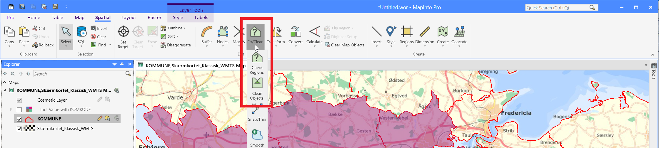
Clean Objects
To fix the issues, you either have to fix the problems manually or use Clean Objects, from the help:
The Clean Objects command removes any self-intersections in your region data and optionally alter region data to remove overlaps and/or gaps. Clean is available whenever there are objects selected, and the table that the objects are in is editable. The Clean Objects command is located on the SPATIAL tab, in the Edit group, click Fix/Clean.
Note: All of the objects selected must be closed objects (for example, regions, rectangles, rounded rectangles or ellipses).
There are several things you should be aware of when using the Clean Objects command. Although Clean Objects works on a selection of objects, it is designed to be used on an entire table at once. If Clean Objects is used on a selection, rather than on the whole table, problems can occur. For example, if not all the objects are included in the Clean Objects operation, some of the object intersections can be missed.
In addition, Clean Objects could introduce new overlaps and gaps if not all of the objects in the table are used as input. The Clean Objects operation places new nodes at the point of each intersection it encounters. The presence of these nodes can slightly change the size and shape of objects, although you would have to zoom in very closely to the site of the new nodes to notice it. These slight alterations have the potential to create small gaps and overlaps in what were previously common boundaries with other objects not included in the Clean Objects operation.
Clean Objects also removes the overlap when one object is completely inside another, however, if one object is completely inside another object, the object which is inside (often smaller than the containing object) remains, while a hole is punched in the containing object. The result does not contain any overlaps.
------------------------------
Peter Horsbøll Møller
Principal Presales Consultant | Distinguished Engineer
Precisely | Trust in Data
------------------------------
Original Message:
Sent: 05-26-2021 06:48
From: Mike Woodbury
Subject: Geometry clean tool (s) for TAB file – polygons please | MapInfo Split Tool 'does not work' on overlapping Obj. / Features
Hi Peter,
I found and ran the Spatial | Check regions (clean tool) in MIP on my file.
It has highlight some errors in the file with red pin and yellow cross overs.
Are these fixed now?
I then tried the clean objects (next button down) after re-loading the file again (unsaved). I'm assuming this file in clean and ready to go now after saving?
Is there a line direction tool in MIP? To make sure all the lines / polygon line directions are one way?
Cheers Mike
Sent from Mike W iPhone
Hi Peter,
Yes, it's set to Aggressive. Will try none tomorrow.
Will also review the cleaning tools in MIP, under spatial.
As I referenced, MIP has many tools with are very effective.
Thank you for the info and help.
Cheers
Original Message:
Sent: 05-25-2021 08:03
From: Mike Woodbury
Subject: Geometry clean tool (s) for TAB file – polygons please | MapInfo Split Tool 'does not work' on overlapping Obj. / Features
Hi Peter,
Do you come across issues with slitting very large files in MIP?
Is there a file size limit? This is the reason extended tab files are used.
We run very large files, and they may be for entire WA, at times.
Cheers
Sent from Mike W iPhone
Hi Peter,
Understand.
I'm setting the bench mark at arcgis pro level. As it cleans / fixes, and MIP does not appear to be doing the same job.
Your replies and support are very much appreciated.
I don't get direct support from MIP. As I am are required to channel support to Discover team. Have been advised of this by MIP support.
I do find there are a lot of tasks that are a lot easier in MIP. It's not all negative.
Thank you again.
Mike
Sent from Mike W iPhone
Original Message:
Sent: 5/25/2021 7:50:00 AM
From: Peter Horsbøll Møller
Subject: RE: Geometry clean tool (s) for TAB file – polygons please | MapInfo Split Tool 'does not work' on overlapping Obj. / Features
Hi
Yeah, I normally have good success with the tool. It tends to mark or fix the issues of self-intersecting objects.
Are you sure you are setting the right expectations for the tools? Split in MapInfo Pro might not work exactly the same way as it does in other products. Similar when comparing the cleaning tools.
Hard to tell without more details.
------------------------------
Peter Horsbøll Møller
Principal Presales Consultant | Distinguished Engineer
Precisely | Trust in Data
Original Message:
Sent: 05-25-2021 07:38
From: Mike Woodbury
Subject: Geometry clean tool (s) for TAB file – polygons please | MapInfo Split Tool 'does not work' on overlapping Obj. / Features
Hi Peter,
Thank you for your reply.
Have you had any luck with MIP cleaning tools?
I'm very annoyed with MIP, as I appears to me, that MIP cannot find or fix issues in a files.
Arc has been able to clean and sort out the file. MIP has not.
I deal with the discover support and they claim there is nothing wrong with the MIP split tool. I disagree 100%. Hence why I demonstrated that Arc can do what MIP cannot do.
Cheers
Sent from Mike W iPhone
Original Message:
Sent: 5/25/2021 7:25:00 AM
From: Peter Horsbøll Møller
Subject: RE: Geometry clean tool (s) for TAB file – polygons please | MapInfo Split Tool 'does not work' on overlapping Obj. / Features
Hi Mike
If you think there is a "malfunction" in MapInfo Pro, please reach out to our technical support at support@precisely.com.
Please include a description of the steps and if possible also include the data. This will make it possible for our support to reproduce and file a bug report. In some cases, they may also come up with a possible workaround or solution.
As for the geometry clean tool, I assume you have checked out Check Regions and Clean Objects commands in the Fix/Clean dropdown on the Spatial tab?
------------------------------
Peter Horsbøll Møller
Principal Presales Consultant | Distinguished Engineer
Precisely | Trust in Data
Original Message:
Sent: 05-25-2021 03:27
From: Mike Woodbury
Subject: Geometry clean tool (s) for TAB file – polygons please | MapInfo Split Tool 'does not work' on overlapping Obj. / Features
Hi,
Please would anyone offer some direction on a geometry clean tool (s) for TAB file – polygons please?
I have a tool in arcgis pro and it has a number of function available to me: Repair Geometry-Help | ArcGIS for Desktop
| Arcgis | remove preview |
| | Repair Geometry-Help | ArcGIS for Desktop | | Inspects each feature in a feature class for geometry problems. Upon discovery of a geometry problem, a relevant fix will be applied, and a one-line description will be printed identifying the feature as well as the problem encountered. Valid inputs are shapefiles, personal, and file geodatabase feature classes. | | View this on Arcgis > |
|
|
https://desktop.arcgis.com/en/arcmap/10.3/tools/data-management-toolbox/repair-geometry.htm -
Does anyone know if mapinfo/discover offer anything please – as I have not been able to find anything on the web and or in the 2019 manual that's comprehensive
The google searches for MapInfo Help is really hit and miss - honestly, wish it was like esri!!
Anyway, I have split my features in ArcGIS Pro for 1,695 new objects. I completed the same workflow in Mapinfo and ended up with 1,180 objects for the same layers? Why the difference? I have put it down to MapInfo/Discover not splitting overlapping polygons, which are left off the MapInfo file
I have also check the outcome (metadata) of my ArcGIS file and I'm happy. I'm not happy with the MapInfo outcome. Errors and incorrectly assigned metadata into the split Mapinfo tab file?
Reason?? Overlapping polygons and the MapInfo split tool not able to handle the process and assign information correctl
Have been trying to solve this issue in MapInfo for 6-months now, and ended up using ArcGIS Pro in then end - Thanks to esri!!! Software that does what it states it can! MapInfo cannot handle the split of overlapping polygon's in the 10's, 100's, 1000's or 100k's. I'm left to split next, an Input file of ~500,000 object and target feature of ~21,000 objects - trying to do in MapInfo over ArcGIS Pro. Looks like ArcGIS Pro will be the only solution??
Cheers, Mike
------------------------------
Mike Woodbury
Knowledge Community Shared Account
------------------------------