MapInfo Pro 2021 Feature Summary
It's time for us to give you a heads up on the progress for MapInfo Pro v2021.
We aim to release it in the autumn, and we are bringing some really exciting things to the product.
Let me walk you through some of the features that are close to being ready, and then give you some ideas on what's more to come.
We currently are running an Alpha/Beta preview in the MapInfo Lab group. If you would like to try out the new features and give us feedback while there is still time, contact @Andrei Veselov to get invited to the lab.
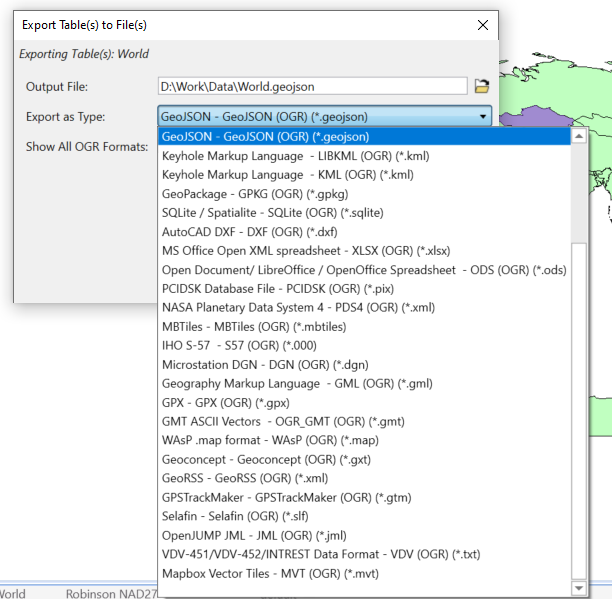
New File format
With v2019, we started including OGR/GDAL in the MapInfo Pro installer. That made it possible for you to take advantage of OGR/GDAL through Python as an example.
With v2021, we are introducing support for OGR/GDAL through a new file format. This means that you can access any format that OGR supports directly from MapInfo Pro.
With access, we refer to
- Directly open with read and write support,
- Import into Native Tab,
- Export to from Native Tab
- and Save as from Native Tab.
We are testing a number of the most commonly used formats, and these will be listed as formats in the File Type list. But you can tell MapInfo Pro to show all the GDAL formats in this list. We just haven't tested all.
One of the benefits of using GDAL is that you get read/write support to formats we earlier only support in read-only mode, such as CSV and Excel. Another benefit is the range of formats supported by GDAL.
These are some of the formats we are testing:
- CSV and TXT (including well known text and geojson geometry support)
- XLS
- WKT
- ESRI Shape
- GeoJSON
- KML and KMZ
Background thread support
When saving a copy of a table, you can now choose to save the table in a background thread. This lets you use MapInfo Pro while the save copy as the process runs.
This is supported for saving (extended) native tables to (extended) native tables and when saving (extended) Native tables to a GDAL format.
We also support background threads to save OGR tables into Native tables and export Native tables to OGR formats.
Export capabilities
These improvements also allowed us to revisit our Export capability. This has now been extended to support the GDAL/OGR formats, export multiple tables at a time and for some formats run the export in a background thread.
WFS 2.0 Support for Paging
The Ordnance Survey has created a new set of APIs that lets you access their data via OGC Compliant web services. MapInfo Pro already supports these services via WMTS and WMS.
For WFS, we have now added paging support that really is required to benefit from the OS Vector API as it is designed to only return a very low number of records per request. With the support for Paging, we can now send multiple requests to the services and in this way get data for a larger area where we earlier only could get a very limited number of records.
WFS 2.0 Paging will work with any WFS 2.0 service that supports paging. If you know of any, please let us know to potentially test these before we release this new capability.
Select by Attribute
With MapInfo Pro v2019, we introduced Select by Location to help users create spatial joins between two datasets. For v2021, we are introducing Select by Attribute which will help you query your data based on attributes.
This new dialog will present the user with an easy-to-use interface where dropdowns will show the unique values for the columns. You will be able to construct queries specifying conditions without having to know SQL. The dialog will allow you to look for one or more specific values, compare numerical values to given values or average values in the column, and locate records where a column holds empty values or has objects of a given type or doesn't have a spatial object at all.
The dialog stays on screen until you actively close it, making it easy to enhance your query until you are happy with the result.

New Time Series Analysis
Flexibly break your data into time periods and visualize them on the map
Utilize full Pro analysis tools such as thematics, querying, labelling etc.
Support playback on the map as well as exporting
Use Time Slider to quickly change the visualization
Annotate the Map with new Smart text and embedded legends
Calculate Statistics on Time fields

Tile Server Reprojection - on-the- fly reprojection for Tile Server and WMTS tables
Below is aerial imagery of London (Bing Hybrid map) in British National gid:

The small but useful things
You can open the Select Projection dialog by clicking on the Coordinate System in the Statusbar allowing you to change the coordinate system in very few clicks. You can also set the map to use the coordinate system of a layer in your map with a single click.
You can make WMS Layer not selectable via the Explorer Window. This is especially useful for WMS Layers that support GetFeatureInfo. This request was raised in the MapInfo Pro community last year.
You can right-click on a table in the Table List to copy the path of the tab file or open Windows Explorer and show the selected tab file. You now also have access to Save Copy As from the Table List context menu which also lets you save copies of multiple selected tables.
We have added another option for closing query tables. MapInfo Pro v2019 added Close Queries and with v2021, we add Close Unnamed Queries. This will close query tables called Query1, Query2, Query3, etc.
On the Layout tab, we have included a dropdown to quickly insert known SmartText Aliases into your layout. This makes it easy to use these and also highlights this capability to the user.
New Support for Layer Filters
Ability to set a "where clause" filter on a map layer to limit which objects are drawn in the map
SQL Improvements
- Changes to cross join support syntax
- Support for non Mappable geopackage (1.2) tables
- New table type OGR
- Ability to refresh a query table without closing it
- Ability to change the query clause of a query table without closing it
MapBasic support for building the ribbon interface
For the MapBasic developers amongst you, there is good news. We finally got around to adding MapBasic support for adding controls to the ribbon interface.
Until now, you have had to use .NET or an additional MapBasic module to easily add controls and modify the ribbon interface.
Now, we have MapBasic statements that support all the capabilities of the ribbon.
MapInfo Virtual Raster support
We are enhancing the support for MapInfo Virtual Raster and adding support for creating these virtual rasters from many of the Raster Procession dialogs.
MapInfo Virtual Raster allows you to create raster grids that refer to other raster grids and modifies these using raster operations. You can use a MapInfo Virtual Raster to merge two existing raster grids into one raster grid. The benefit of the MapInfo Virtual Raster is that the calculation is done real-time and so no additional MRR files are created on disk.
Thanks to @Peter Møller for most of this content.
------------------------------Bob FortinSoftware Architect and Distinguished EngineerMapInfo Pro Development Team------------------------------
------------------------------
Bob Fortin
Software Architect and Distinguished Engineer
MapInfo Pro Development Team
------------------------------